Monday, September 30, 2013

September 30, 2013

Our first full day at Coeur D'alene resort started a little on the cool side and crept up to about 52 degrees.  That however didn't stop Tom from attending to business.  He was at the golf course by 7:15, first off the tee.

The driving range is out on the lake.  The yardage markers are buoys and the balls are all floating balls.


This wasn't just any golf cart.  Electric cart with tilt steering wheel, heated seats, and customized with unique trimmings such as rims, ice chests, brake lights and more.


All the amenities that one could ask for including 5 different places to eat.


The famous island green.  The pin was 182 yards into the wind today.  The ball stayed dry.


The island green drop zone was overly generous today.


Bob the caddy did it all.  The boat was actually steered by an cable underwater.


Located on the south shore of Lake Coeur D'alene.


Many boats are anchored here on 2 sides of the resort.


Exactly what we did!


Found Grammie trying to hide behind the fish tank.


Could those be strawberries hidden inside?

Sunday, September 29, 2013

September 29, 2013

We crossed another time zone today once we hit Idaho.  We left Meadowlake Resort after enjoying a relaxing week, only disappointed that there wasn't enough sun.


Strange weather pattern.  Leaving Columbia Falls to the east...clouds, still a pretty view though.


 Yet, on the other side of the road, sun was shining off the mountains.


 The view over Flathead was great.  We drove along the lake for several miles before heading further west.


 For someone that has an inkling for old barns, this would have been a great study.  It was on the Flathead Indian Reservation in western Montana.


 The mountains along the way were a lot less forested until we got to the Lolo National Forest where it became more mountainous.


 Wonderful countryside...and a river runs through it.


 Alice was looking through the AAA travel book and as usual mentions what became another great find.  Wallace is a city that is listed on the National Historic Register.  What makes this nice is that fast food chains can't make their way into the city because of it.  It was named the Silver City due to the fact that it was the leading US city in Silver mining.


 There have been some important regulations implemented for the safety of the miners.  Some so simple...


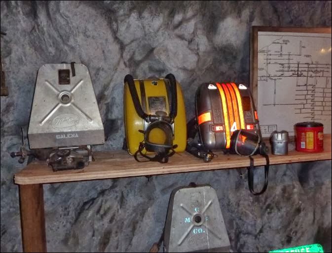
 A diamond tipped drill used to take core samples giving them information on where to drill.


 Safety Air packs used over the years.  The yellow one in the middle has oxygen tanks which can be more hazardous in case of a fire.  The little container just to the left of the coffee can converts Carbon Monoxide into Carbon Dioxide which can keep a miner alive for about an hour.


When they do some blasting, it is intricately done through precision blasting that will create a hole 8 feet by 8 feet by 8 feet dropping the material on the floor of the mine shaft.


 The tunnels have to be pumped out on each day as water collects.  This series of old water filled downshafts goes down 200 feet.


 These are some different samples.  Most contain Galena which is often found with Silver.  The lower one on the right was said to be about 95 % Silver.  It doesn't look it but remember, Silver tarnishes black.
In 2011, the area mines were responsible for 5.3 million ounces of Silver being mined.   At today's prices, about $100 million.


 Part of the tour ride to the mine included a quick tour of the city.  Just a quick stop here.

We finally arrived in Coeur D'alene for 3 days.  A little upscale, but we'll try to manage weather permitting.


Saturday, September 28, 2013

September 28, 2013

Looks like our plans for today might have changed.  Whitefish, only a few minutes away, might have something for someone of slavic decent.

Whitefish Oktoberfest

Will let you know later if you have to send bail money.

Between the time this day's blog started and the time we got into the car, plans changed.  We decided to head back into Glacier NP.


On the way to the park, we go through a small town called Hungry Horse.  Erma makes about 3700 pies from scratch during a year.  She is only one of many that make them.  A huckleberry is similar to a blueberry only Hucks have seeds.  The average price for a slice is about $4.50 and the price seems to be the same everywhere.


The Hungry Horse clearing ball is 9000 pounds, is 8 ft in diameter, and was used to clear land in 1950.  It was hauled with tractors by cable and could clear the land at a walking man's pace.


On the way into the park it looked like the weather was going to clear until we looked a bit closer.


Today we got as far as the loop ...about 24 miles into the park.  By coincidence, we followed another Maine car.  It was the 2nd seen in 2 days.

This pic was taken looking down over the edge at the Loop, a hairpin turn.  It is also where the road was closed up to Logan Pass.


On the way back down, there are several areas where the heavy rains and snow caused a wash. These areas are common with steep slopes.


Up on a side road on the way back to town is the Hungry Horse Dam.  It is the 11th tallest US Dam.


Quite often there will be an area where a health stand of trees exist.

September 27, 2013

Today was one of those lazy days where there weren't really any plans.  We thought about getting up bright and early but when we looked out the window.......


The day started off around 29 degrees, got up to about the mid 50's and then dampness set in and it got chilly. We heard that home in Newport it was 65 in the morning. Tom played golf and Alice worked on  knitting projects.  We went out for the evening meal and the place was packed.  Here in Montana gambling and Casinos are legal so many restaurants have a place out back for recreation.  Did I say that many town have no sales tax?  However some do.  Whitefish, the next town 10 miles away does because they have more tourists in the summer because of the park and in the winter there is skiing nearby.

Tomorrow, another attempt to go hiking up near Logan Pass...and then maybe going to Whitefish for their Octoberfest days.


Thursday, September 26, 2013

September 26, 2013

Today we got off to the usual late start.  We wanted to go back up to Logan pass and hike a trail but at the gate, they said that the road wasn't open that far.  We changed plans and decided to drive around the south side of Glacier and head to Two Medicine.  We followed Route 2 (I think it is the same one that goes through Newport ME) for a little over an hour and passed some wonderful sights.  For a ways, it runs along 2 sets of train tracks for freight and AMTRACK. 


Our first stop was at the APGAR camping area at the southern end of Lake McDonald


We exchanged pictures with another couple.  Luckily we had the right cameras.


 If you ever plan to come to Glacier and stay at the Village Inn....


 this is what you will see out your front window (snow maw not be included depending on time of year.

 Along Route 2 there were a couple of roadside pullouts (actually many) for taking pictures.  This is Flathead River.


 The mountains to the north have had snow on them for a couple of days although not heavy.


 Wonderful views!


 As we entered the Blackfeet Indian Reservation the other side of the mountains came more into view.


 Lower Two Medicine Lake looking northwest.


 Running Eagle Falls.  The falls during the low runoff season come out under a layer of rocks.  During the high water season it also spills over the top of the rocks.


 From the end of Two Medicine Lake you can get an excellent view of Sinopah Mountain at 8271 feet.


Two wild animals didn't materialize today so we got a pic of the next best thing.

We returned later in the afternoon in time to take a little walk around the resort.

September 25, 2013

Today started out looking pretty bad weather wise but we decided to head back to the mountains anyway.  Tom figured we could go looking for bear so he loaded up Alice's pockets with honey nut granola bars and some huckleberries...that should do the trick. Huckleberries are to Montana like blueberries are to Maine...a cash crop. After driving to the park entrance we decided to hike the Avalanche Lake Trail.
We are 2 miles from the lake, we've got a bottle of water, 4 granola bars, it's 45 degrees and we are wearing sneakers. (credits to  Blues Brothers for those that got it)  Besides that, we were not the oldest ones on the trail.  There was one woman wearing her slippers on the Cedar Trail which was actually a boardwalk for a short distance.

 These first 2 pictures show that the leaves haven't really changed much so far.


Before we got to the Avalanche Lake Trail there was a boardwalk that took us through a stand of Western Red Cedar.


 Some of them can grow as big as 13 feet in diameter as high as 230 feet, and can live for 1000 years.


 These small brooks were more active because of the light snow melt.


 You can see little streams of water coming down the mountains.


 This is a closeup of the previous picture for those who don't always wear their reading glasses.


We only got up to about 3300 feet today with a temp of 45 degrees.  it's is still another mile up to Logan Pass and another 4000 feet up to some of the mountain tops.


 You can feel the cold can't you?


The other day I mentioned that the predicted date for the last glacier to disappear was 2040.  The real date is 2030.  Don't worry, maybe they can petition for a change in the name of the park to "No Global Warming Here" National Park.


 We finally reached Avalanche Lake.  The lake was cold, greenish colored, and quite clear.  With all the other people around we decided that it was OK to have a granola bar and not worry about being bear food.


 Grammie did great hiking.  She kept the pace up in front and nobody passed us on the way up but we did pass several couples. 


 On the way back down we finally spotted some wild animals foraging for food.  I think they could smell the empty granola packages in our pockets.

It turned out to be a great day.  On the way back to Columbia Falls we had a piece of Huckleberry Pie...with Ice Cream.